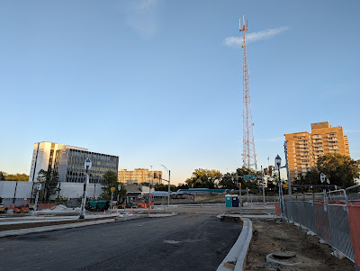
The deadline for the reopening of the road network in the Westbard area of Bethesda is only 11 days away. Contractors have installed the new street lamps along the sidewalks. Most are still wrapped in plastic to protect them prior to activation. It appears that utilities have indeed been undergrounded along this stretch of the former Ridgefield Road between Westbard Avenue and River Road. The utility poles that ran along the Westwood Center II side of that block of Ridgefield are gone, an interesting development given that the Montgomery County Council did not require utilities to be buried in the 2016 Westbard sector plan.
There are now traffic signal arms erected in all directions at the future T intersection of the realigned Westbard Avenue and the residential block of Westbard between Ridgefield and River. Hopefully this means there will be signal control at this intersection, which would solve what would be highly-dangerous vehicle turns across oncoming traffic for drivers and pedestrians. Pedestrian signals have been installed at the intersection, also still mostly bagged for protection.
New signage, and a road grid realignment that really wasn't fully thought through when recommended in the 2016 plan, are going to continue to be a source of confusion for non-residents. For example, a short stub of lopped-off Westbard between the "new" Westbard Avenue and Ridgefield Road has been turned at an angle, creating an odd and tiny island of land that didn't appear in the 2016 sector plan. That is County property in the former Westbard right-of-way, but also sits alongside a private home. What is going to be on it? It wasn't part of any public plan or discussion, and was never shown on maps at public meetings, but...here it is. The angled road also cuts down on the buildable area for the EYA townhomes planned for the former nursing home property.
To add to the intrigue and disorientation, the street signage facing drivers turning from the residential block of Westbard onto the commercial Westbard Avenue now says "Brookside Dr 5600," with an arrow pointing left, and "Westbard Avenue," with an arrow pointing right.
 |
| New streetlamps |
No official announcement has been made about any of these matters, but some are asking if this means Montgomery County is going to redesignate the former block of Ridgefield between Westbard and River - which was always meant to be an extension of Westbard Avenue to River via this realignment project - as a new block of Brookside Drive. That doesn't seem smart - - but it appears to be true, as the new arrow sign refers to "5600" Brookside Drive, and first block of the long-existing Brookside Drive across River in Kenwood is 5700 Brookside.
I can't think that Kenwood or Westbard developer Regency Centers would be pleased by this development. Brookside has always been a Kenwood-exclusive address, and the new designation creates a new relationship between the heavy commercial traffic coming down from Westbard and the "next block of Brookside" in Kenwood, exactly the opposite of discouraging cut-through traffic from using Kenwood as a short-cut. A new Brookside-River-Brookside intersection would be a bummer for Regency Centers, too, in losing the prominent "Westbard" connection and signage at the heavily-traveled River Road intersection, when their development is branded as Westbard Square.
 |
| What is this new island of land? Who controls it? What will it be used for? |
Again, were all of these issues really thought through to their logical outcomes? It's not like there weren't years of delay between 2016 and 2022, during which all of this could have been hashed out with thoughtful common sense. Perhaps if the after-sector-plan deliberations and decisions had been made in a public process, rather than behind closed doors, these issues could have been pointed out and avoided.
 |
| New street lamp at the base of Ridgefield Road at Westbard Avenue |


1 comment:
Robert,
This post reminded me of a possible change to another popular intersection at Fernwood and Democracy Blvd. There's current construction there and it appears that the traffic flow may be returned to allow cars to go straight thru Fernwood in the direction of Mont. Mall and the former Marriott HQ and vice versa. The traffic pattern, quite a few years ago now, used to be left, right and straight at that intersection. To be able to go straight on Fernwood from both sides of the intersection would be great especially from the mall and avoiding going up to Rockledge just to get to Fernwood Road. Anything you can find out about what the changes being made there are all about would be helpful. Thanks!
Post a Comment