The Gables White Flint development will create the greatest physical alteration of today's White Flint of any project to date. Not merely a teardown of an existing structure on a property, the Gables will remove part of Executive Boulevard, as well as surface parking lots, and require a new street grid, as laid out by the White Flint Sector Plan.
The Gables White Flint will consist of three interconnected buildings of 68, 58 and 36 feet, respectively, that step down in height towards Old Georgetown Road. A 54' parking garage will serve all three buildings. The garage will also include 400 public parking spaces. Part of that is to compensate for the demolition of the Wall Park parking lot. According to Montgomery County Planning Department documents, the garage will not have a sprinkler system. In response, Montgomery County Fire and Rescue has advised it will require additional vehicular access to the site.
The other surface parking to go will be 22179 square feet from the North Bethesda Marriott Conference Center.
490,000 square feet of the mixed-use Gables project will be dedicated to residential use. 31,000 square feet will be non-residential, primarily on the eastern side of the property.
The Gables will be bordered by Old Georgetown Road to the west, Wall Park to the south, the future Market Street to the north, and the future Grand Park Avenue to the east. The project cannot begin until Montgomery County builds the latter two roads.
These renderings don't appear to be the actual designs for the buildings yet, so I can't really critique them at this point.
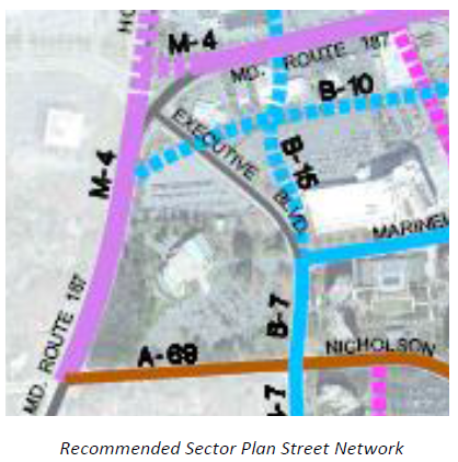
Two disappointing aspects, however, are that a) the retail does not appear to extend along the length of Market Street, defeating a standard urbanist tenet of activating streets via storefront activity, and b) the grand, sweeping curves of Old Georgetown Road and Executive Boulevard will be lost to a tired, standard street grid.
Furthermore, the sharp right turn of the new Old Georgetown Road will be far less efficient in moving traffic than the existing curve. It also sets up a confusing scenario for tourists, similar to that of MD 27 in downtown Damascus. Essentially, you have to turn onto another road to stay on the road you're on. Makes a lot of sense, right? Wrong, and such confusion reduces driver and pedestrian safety.
Of course, all of those changes are not entirely related to the Gables alone.
The Gables sketch plan will go before the county Planning Board on Thursday, October 24.
Images courtesy of Montgomery County Planning Department.


No comments:
Post a Comment