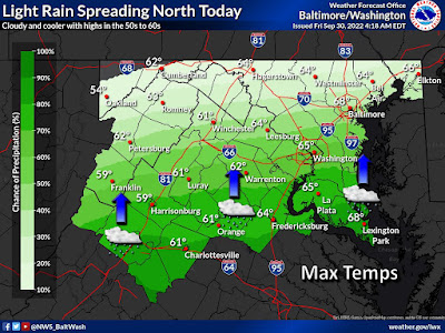
The first outer rain bands of Hurricane Ian will reach the Washington, D.C. metropolitan area around the middle of this afternoon, as D.C., Maryland and Virginia get their first splash of what will be a very wet weekend. Around the same time, Ian will make its third landfall on the coast of South Carolina. Accuweather forecasts a storm surge of 3 to 6 feet in South Carolina, with the greatest impacts north of Charleston, and in the vicinity of Georgetown and Myrtle Beach. The South Carolina and Georgia coasts could experience a total rainfall of 8 to 12 inches, and up to 18 inches in some spots. Rainfall will likely total 4-8" in North Carolina, Eastern Tennessee, Virginia and West Virginia.
Here in Maryland, the localized flood risk will first loom tonight, and today will feature the highest wind gusts of 37 MPH. Winds will drop to gusts of 21 MPH on Saturday and Sunday, Total rainfall in Maryland and Montgomery County is expected to be about 2 inches over the weekend. However, if Ian were to move out over the ocean again or stall over our area, that total could more than double. So be prepared for all potential outcomes.
As of 5:00 AM this morning, the National Hurricane Center reports Hurricane Ian's current location is 145 miles SSE of Charleston, South Carolina. It is moving NNE at 9 MPH. Ian's current maximum sustained winds are measured at 85 MPH.
Graphic courtesy National Weather Service

No comments:
Post a Comment